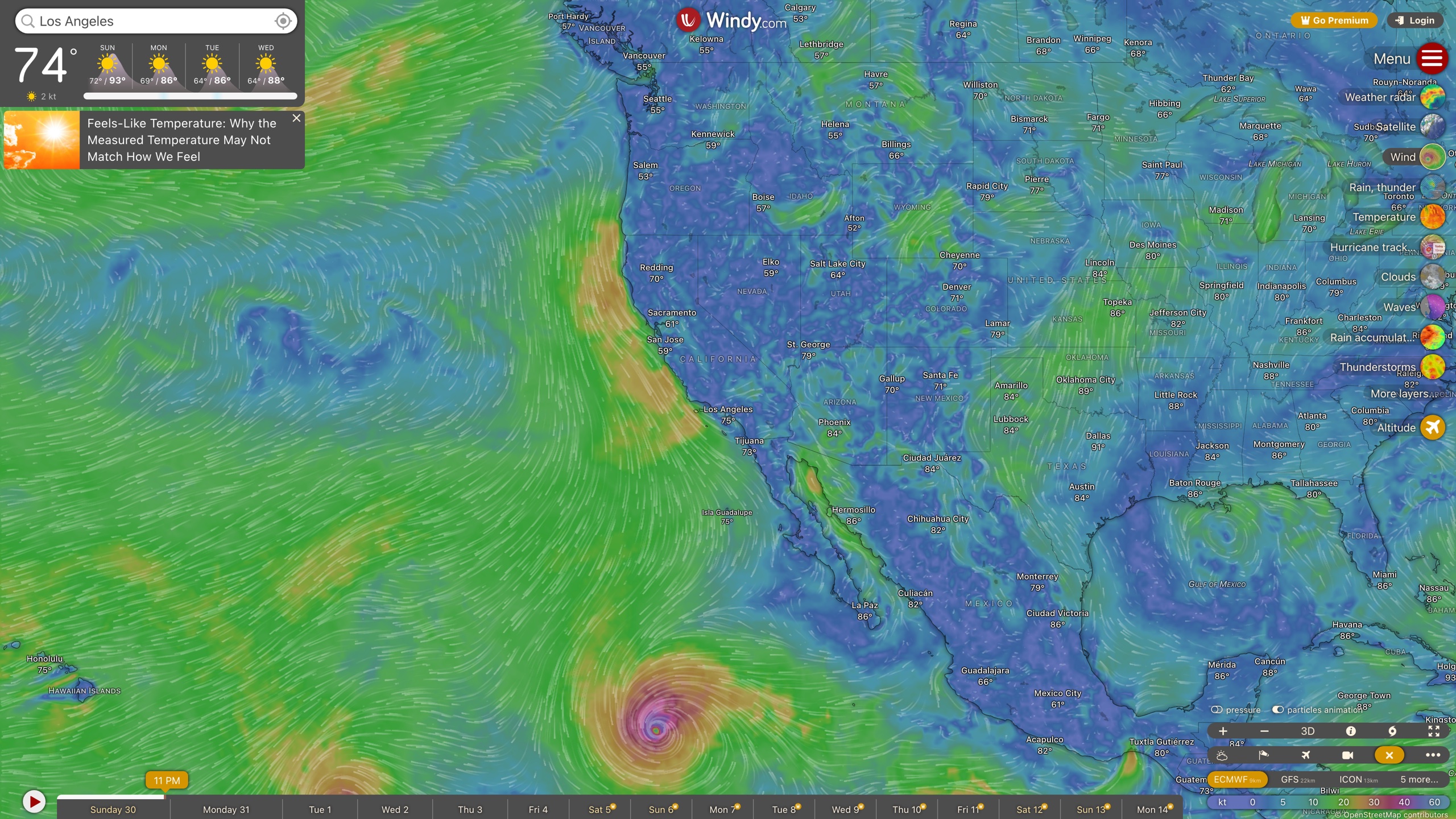
Windy (windy.com) is an interactive global weather visualization platform. On a zoomable animated map it overlays wind-particle animation, weather radar, satellite imagery, temperature, waves, air quality and dozens of other layers, and it can compare the output of several numerical weather prediction models — ECMWF, GFS, ICON and more — for the exact same spot. The problem it solves is turning raw meteorological data published by specialist agencies into maps that non-experts and outdoor professionals can read directly. Compared with traditional, text-table-first weather websites, its verifiable distinctions are multi-model comparison on one map, professional layers and tools for aviation and marine use, and an explicitly permissive license for reusing its visualizations.
At a glance
- URL: https://www.windy.com/
- Type: Weather data visualization / forecasting
- Cost: Core features free; Windy Premium at 37.99 as a one-time one-year purchase (subscription page, as of 2026-09-01)
- Registration: Most of the service works without an account; the Terms of Use state that services are generally available to both non-registered and registered users, while features such as favorites and custom alerts require an account
- Interface languages: The official translation post states more than 40 languages via community translation on Crowdin; Simplified and Traditional Chinese interfaces were both verified in testing
- Mobile: iOS / Android apps (launched 2016); Google Play shows 50M+ downloads (store listing, as of 2026-09-01); Apple Watch and Wear OS are also supported (official blog)
Background
Windy was created in November 2014 as a personal project by Czech programmer Ivo Lukačovič — also the founder of the Czech portal Seznam.cz, and himself a kitesurfer and pilot — under the name Windyty. In his pinned post on the official community forum, he describes being inspired by products from the Swiss company meteoblue and by "Earth", an open-source project that animated wind particles on a globe; he rewrote Earth's open-source code and struck a data agreement with meteoblue.
Key milestones from that official account: iOS/Android apps launched in 2016 alongside a rename to Windytv ("which turned out to be a big mistake"), and the ECMWF model was added the same year; in 2017 the service became Windy at windy.com, and that hurricane season it became a major weather information source for governments, institutions and individuals in affected areas; 2019 brought the satellite layer and route planner plus the integration of the webcams.travel and lookr.com webcam sites; 2020 introduced 1-hour forecast data updated four times a day with Windy Premium; 2021–2022 added the ICON model family, air-quality monitoring stations, Apple Watch support, and the HRRR and ACCESS regional models.
The operator is Windyty, SE, registered in Prague, Czech Republic (company ID 04641647) — a private company owned by its founder and employees (Terms of Use, About Windy). In June 2024, Windyty announced it had acquired a majority stake in Swiss weather company meteoblue; both products continue to operate independently.
Core capabilities
Animated weather map and layer system
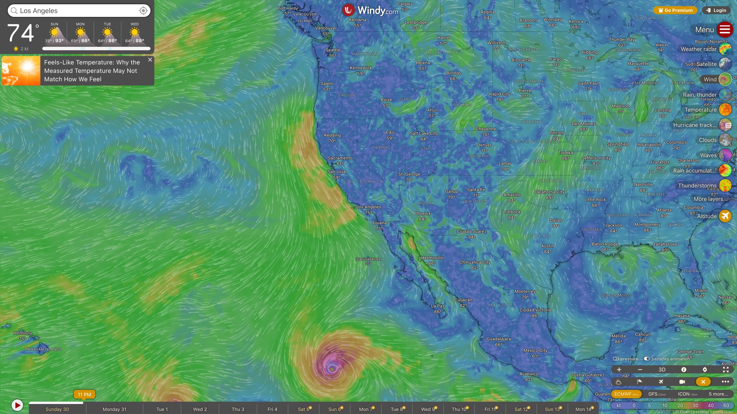
Windy's main view is a zoomable world map with animated wind particles. The right-hand layer bar is grouped by theme; as verified on 2026-08-30 it includes weather radar, satellite and a hurricane tracker; wind (speed, gusts, accumulation); temperature (dew point, humidity, wet-bulb, solar power, UV); rain and snow (precipitation, accumulation, new snow, snow depth, precipitation type, thunderstorms); clouds and aviation (high/medium/low clouds, fog, cloud tops and base, visibility, CAPE index, thermals, icing, freezing altitude, clear-air turbulence); sea (waves, swells, wind waves, sea temperature, currents, tidal currents); air quality (AQI, NO₂, PM2.5, ozone, SO₂, CO, dust); and drought and warnings (drought monitoring, fire danger, weather warnings, avalanche risk) — dozens of layers in total.
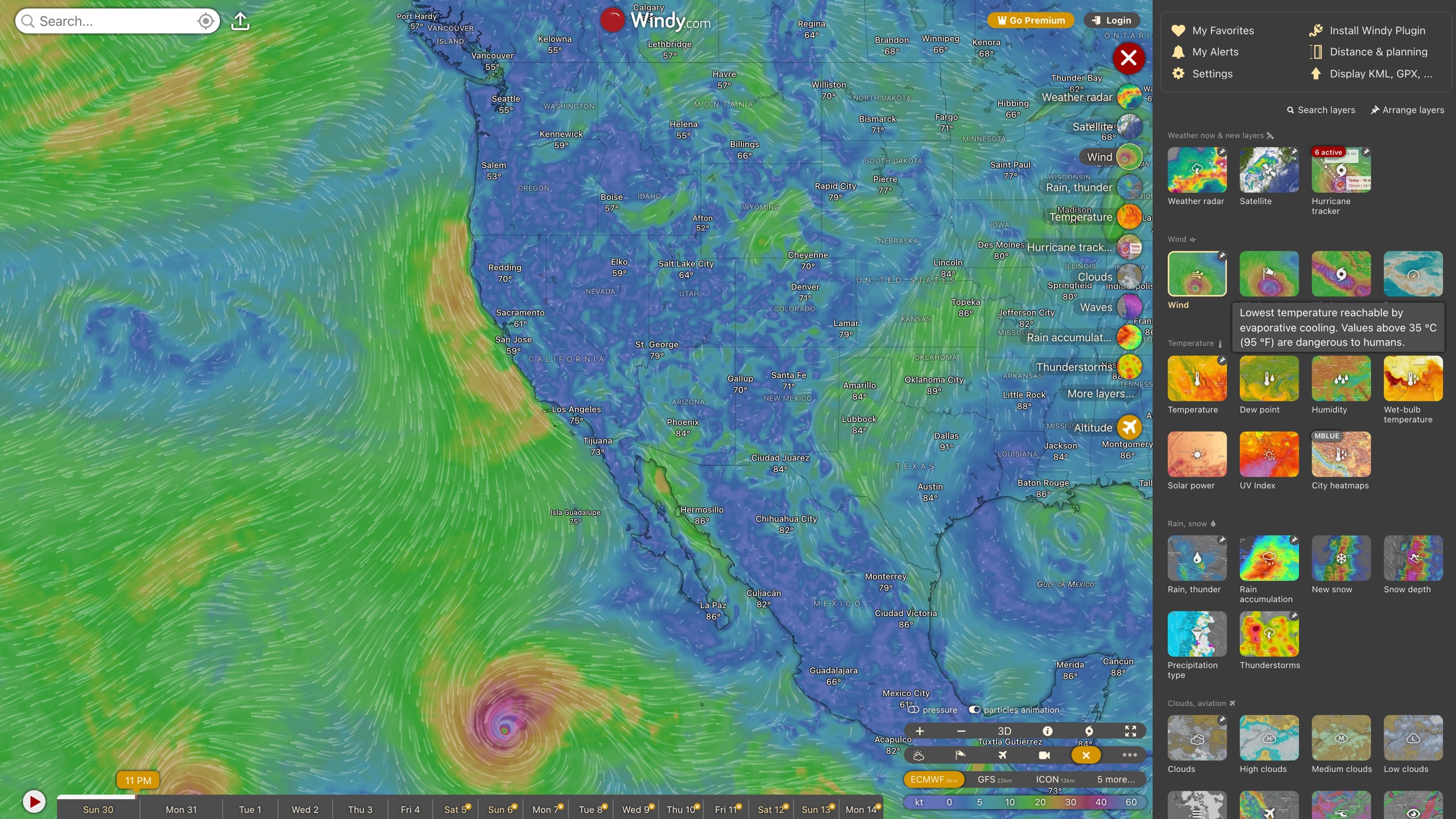
The map can also display points of interest: airports with METAR/TAF reports, weather-station observations, webcams, paragliding/kitesurfing/surfing spots, active fires, air-quality stations, radiosondes and tide forecasts. Base-map labels come from OpenStreetMap.
Multiple forecast models and comparison
Windy does not produce its own forecasts; it visualizes the output of numerical models run by meteorological agencies. According to the official data-source post and the Wikipedia entry, the global models include ECMWF (9 km resolution), the US GFS (22 km), Germany's ICON (13 km) and meteoblue's models; regional high-resolution models are offered where coverage exists, such as ICON-D2 (2.2 km) and AROME (1.25 km) in Europe, HRRR (~3 km) and the NAM family in the US, HRDPS in Canada, and ACCESS in Australia. For any location you can switch between models, or use the compare feature to see where models agree or diverge on temperature, precipitation and wind — a standard way to judge forecast confidence.
Point forecasts and specialist tools
Clicking anywhere on the map opens a picker with observed/interpolated values for that point; one more click opens the detail panel with tabs for Basic, Waves & Tides, Meteogram (time-series chart), Wind, Pollen & Air Quality and Airgram (vertical atmospheric profile), with a model switcher inside the panel. A side panel lists the point's coordinates, timezone, sunrise/sunset, elevation and the model's terrain elevation — a large gap between the two hints that local forecasts may be less reliable there.
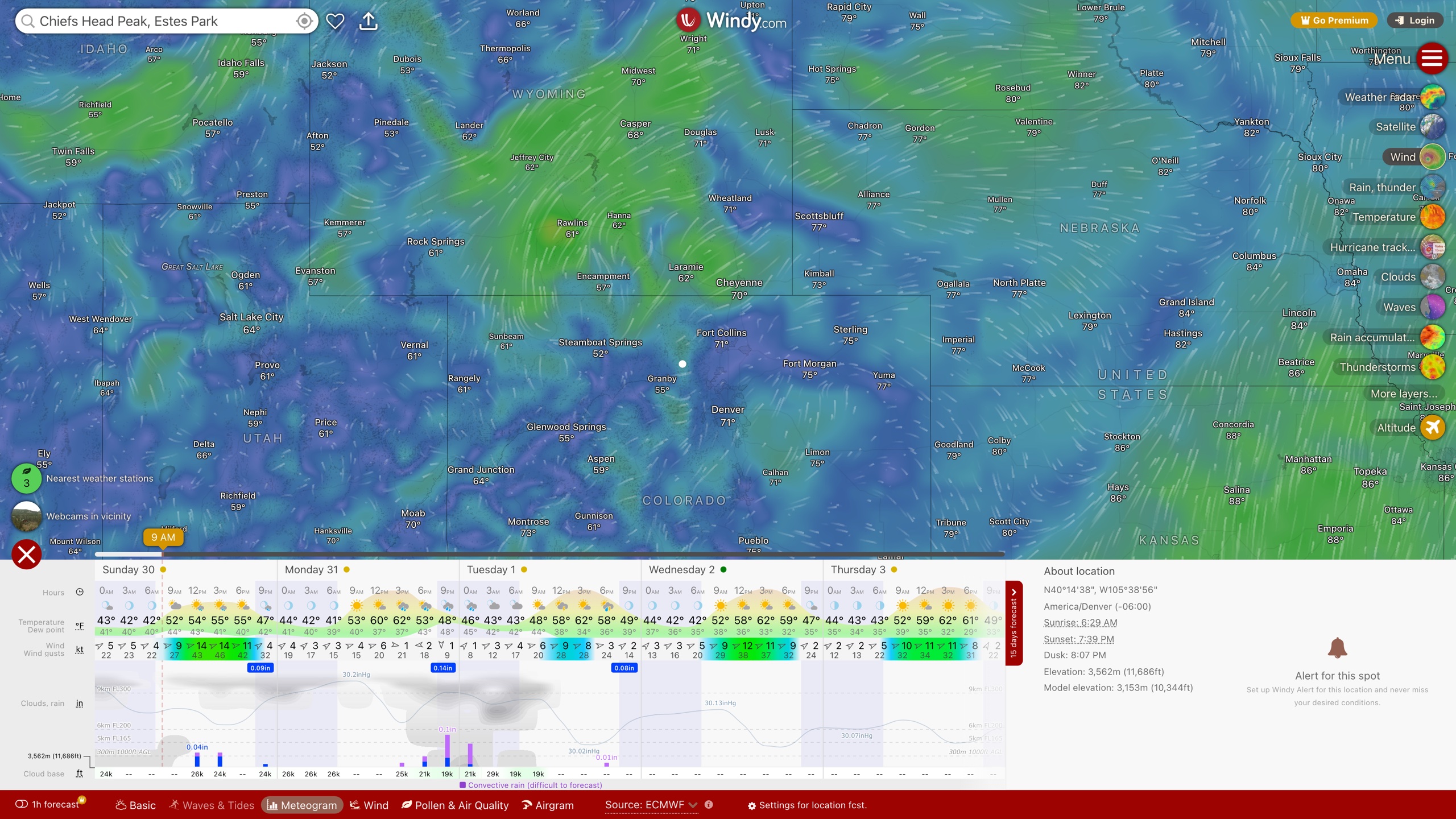
Scenario-specific tools include the route planner (Distance & planning, showing weather along a walking/flying/sailing route at your speed), KML/GPX track import, a desktop-only 3D globe mode, the hurricane tracker, a free embeddable widget for third-party sites, and a community-built open-source plugin system.
Accounts and developer access
Accounts are free, with email or Google, Apple and Facebook social login, and they sync favorite locations, custom weather alerts, layer and unit settings; a Premium subscription is tied to the account and applies across devices (official Premium overview).
Developer-facing products live at api.windy.com:
- Point Forecast API: machine-readable forecast data for given coordinates. A free Testing tier returns randomly shuffled, slightly modified data for development only (500 requests/day); the Professional tier costs €990/year (10,000 requests/day, negotiable). Due to licensing conditions ECMWF is not included; available models include arome, iconEu, gfs, the nam family and cams (pricing page, as of 2026-09-01).
- Map Forecast API: embeds Windy's map engine in your own product with custom data overlays.
- Webcams API: live imagery from its worldwide webcam network.
In addition, Windy Stations lets personal weather-station owners share observations, and users can submit webcams — both supplement its observation data.
Copyright and content policy
Windy's reuse policy for visual content is unusually permissive: Section 8.4 of the Terms of Use grants a worldwide, non-exclusive, royalty-free license allowing anyone — including for commercial purposes — to use Windy screenshots, animations and screen recordings in films, TV, web pages, articles and other media. The conditions are attribution (the Windy logo or "Source: Windy.com", with a hyperlink where possible on the web), no modification beyond necessary adjustments such as scaling, and fair use not contrary to Windy's interests; Windy reserves the right to revoke the permission. The official FAQ states the same policy. This is why news outlets routinely broadcast Windy imagery.
For user-contributed content, the community forum, webcams and personal weather-station data are uploaded by users and governed by the User Content rules in the terms. The Privacy Policy commits to GDPR compliance and promises to "never sell your personal data to third parties"; data shared with hosting and analytics partners must also meet GDPR standards.
Where it fits
- Planning wind-, wave- and cloud-base-sensitive outdoor sports: paragliding, kitesurfing, sailing, skiing;
- Aviation and marine users checking upper-level winds, turbulence, icing and route weather (METAR/TAF reports and VFR/IFR route modes included);
- Tracking storm tracks and intensity in typhoon/hurricane season, overlaid with live satellite and radar;
- Photography, travel and agriculture scheduling that needs an hourly weather window;
- Everyday checks of air quality, dust and pollen (Pollen & Air Quality tab);
- Teaching and media production that benefit from freely reusable weather visualizations.
Limitations
- The free tier uses 3-hour forecast steps with model data refreshed twice a day; 1-hour steps, updates from every model run, HD terrain-aware layers, and extended radar/satellite loops and archives are Premium-only (official comparison, subscription page).
- Regional high-resolution models cover specific areas only (HRRR, for example, is limited to the continental US). Outside those areas only global models are available, and local forecast skill drops in complex terrain; the gap between model terrain elevation and actual elevation in the detail panel is a useful clue.
- The Terms of Use state the service is provided "as is", with no guarantee of accuracy, completeness or timeliness. Windy is a visualization of model output, not an official warning channel — safety-critical decisions should rely on national meteorological services.
- ECMWF data is not available through the Point Forecast API due to licensing; developers who need raw ECMWF output must look elsewhere.
- A few features, such as the 3D globe, are desktop-only, and the web app is a heavy interactive application with a sizeable initial download.
Alternatives
- Ventusky: another Czech weather-visualization site with a similar feel but different layer and model choices.
- Zoom Earth: focuses on near-real-time satellite and radar animation with fewer forecast models and a lighter interface.
- earth.nullschool.net: the open-source global wind/ocean visualization project that partly inspired Windy.
- meteoblue: Swiss high-precision forecasting provider, part of the same group as Windy since 2024, aimed at enterprise data needs.
References
- Windy homepage (2026-09-01)
- Windy Premium subscription page (2026-09-01)
- Why Upgrade to Windy Premium? Here's the Full Breakdown. — official blog (2026-09-01)
- About Windy — pinned post, Windy Community (2026-09-01)
- What source of weather data Windy use? — official FAQ (2026-09-01)
- General Terms of Use of Windy Services (2026-09-01)
- Windy.com Privacy Policy (2026-09-01)
- Windy API and Point Forecast API pricing (2026-09-01)
- Can we use pictures, animations or videos from Windy...? — official FAQ (2026-09-01)
- Help us translate Windy — official FAQ (2026-09-01)
- Windyty, S.E. Acquires Majority Stake in meteoblue, A.G. — meteoblue blog (2026-09-01)
- Windy.com — Google Play listing (2026-09-01)
- Windy (weather service) — Wikipedia (2026-09-01)