Felt (felt.com) is a cloud-native GIS (geographic information system) platform built by Felt Maps, Inc. in Oakland, California. You drag a spatial file — Shapefile, GeoTIFF, CSV and many other formats — into the browser and get a map, then edit it with colleagues in real time, Google-Docs-style. The problem it addresses is that work produced in traditional desktop GIS (ArcGIS, QGIS) is hard to share and collaborate on. Its verifiable differentiators, per the official site, include the no-wrangling "Upload Anything" import, map-level real-time multiuser editing and comments, embeddable interactive maps, and live layers connected directly to cloud warehouses such as Postgres and Snowflake. The company was founded in 2021 and has closed three institutional funding rounds (official 2025 announcement).
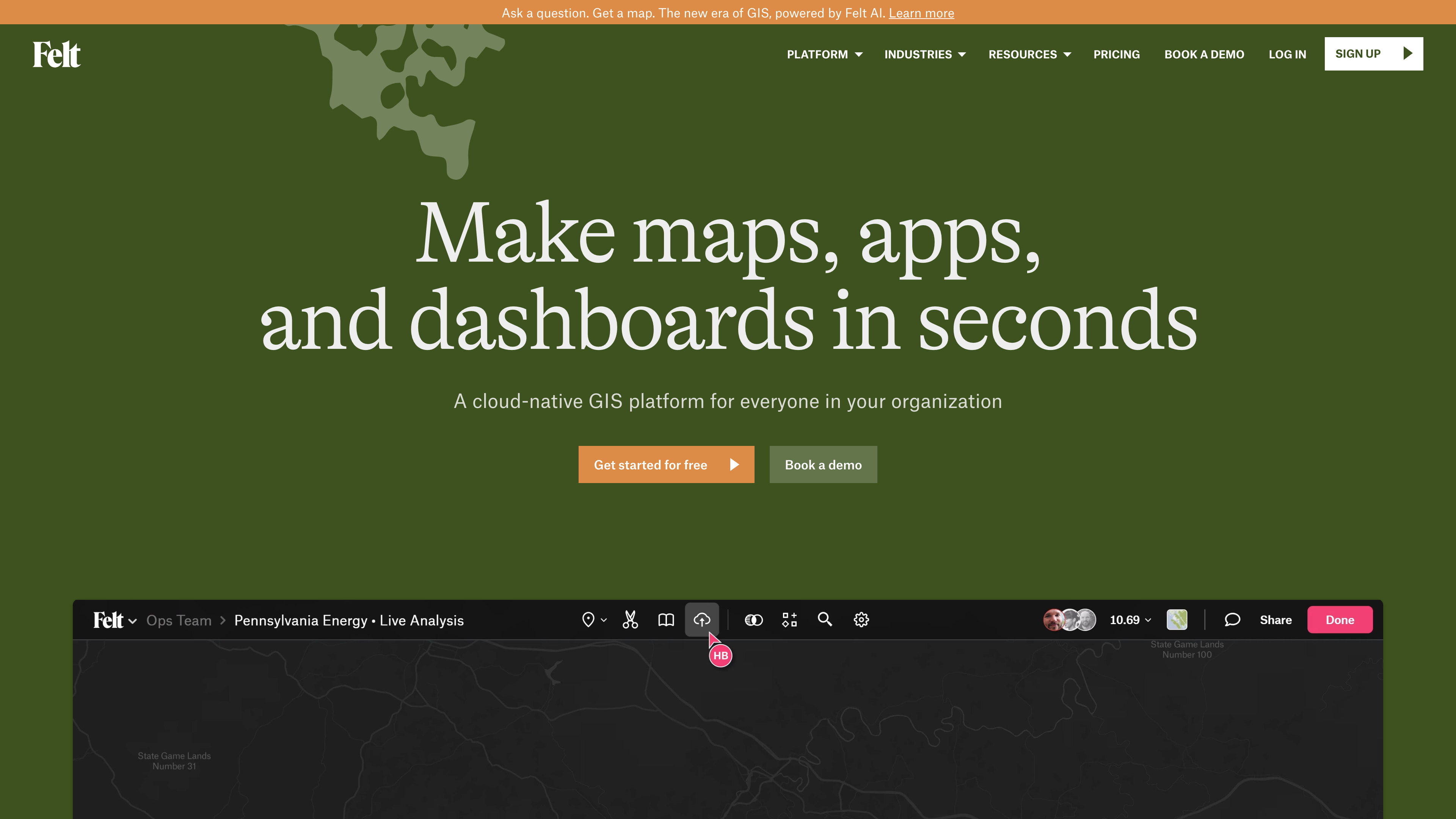
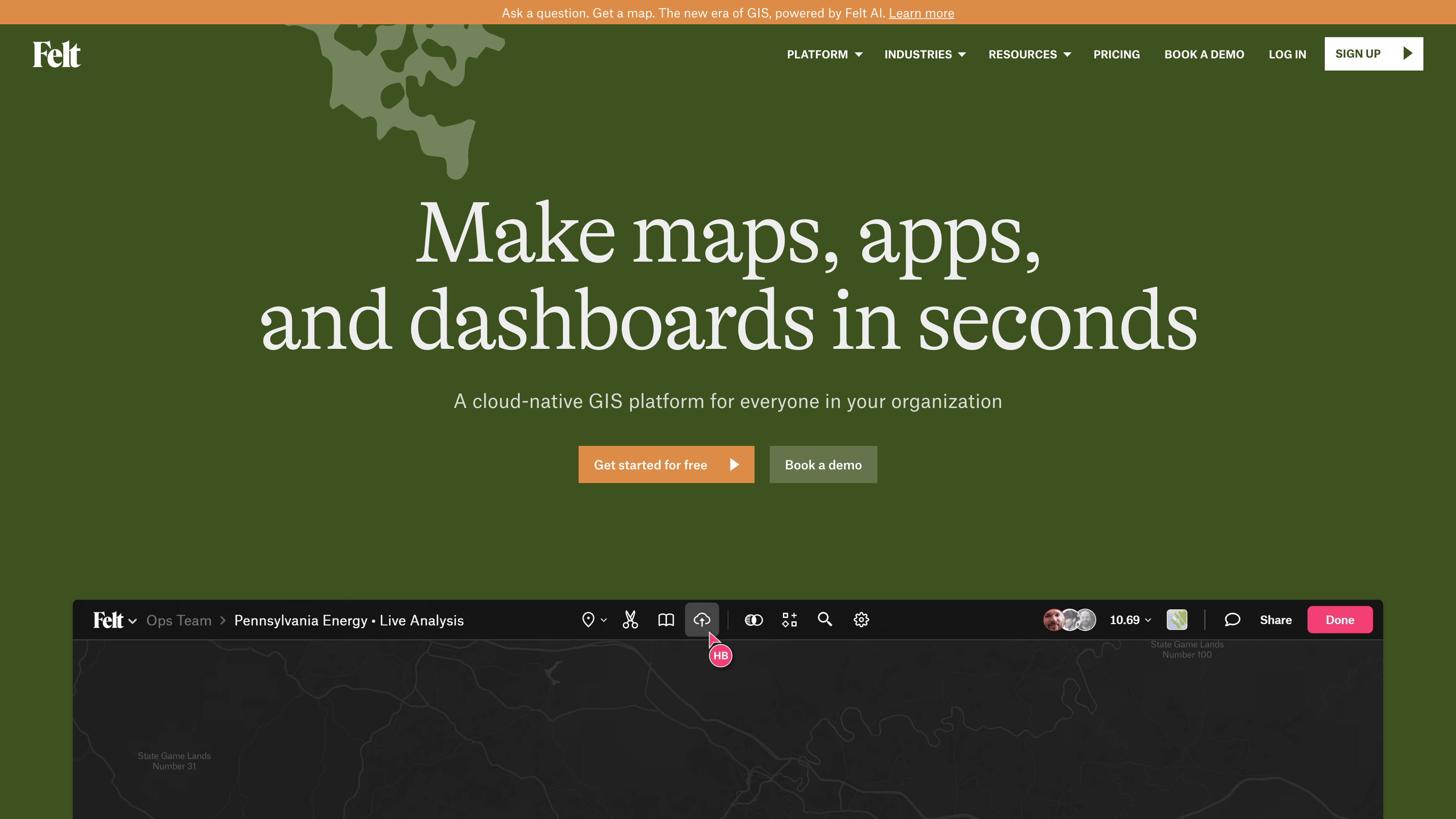
The screenshot above is Felt's homepage. The hero states the positioning — "a cloud-native GIS platform for everyone in your organization" — and the product demo below it shows a map workspace with collaborator avatars and a share control, the core difference from single-machine desktop GIS.
At a glance
- URL: https://felt.com
- Type: Cloud-native GIS / collaborative mapping SaaS (B2B, with a free personal tier)
- Cost: Personal plan free (no uploading your own data files, no commercial use); Professional and Enterprise are annual contracts with unpublished prices (per the official pricing page as of 2026-09-25)
- Sign-up: Browsing the site and public maps requires no account; using the product requires registration (email or Google sign-in) and starts a 7-day Professional trial by default — no credit card
- Interface language: English only; no language switcher found on the site or help center (checked 2026-09-25)
- Platforms: Web (Chrome/Safari/Firefox/Edge); field app for iOS/iPadOS/Android
Background
Felt was founded in Oakland in 2021. According to first-hand TechCrunch coverage, the co-founders were Sam Hashemi and Can Duruk: Hashemi was previously CEO and co-founder of Remix, a city transportation-planning company born out of a Code for America hackathon and acquired by Via for $100 million in 2021; Duruk previously built products at Uber and data-security company VGS (TechCrunch, 2021). Note that the current About page lists Sam Hashemi and Rachel Zack as the founders ("they met at Remix") — a different framing from the early reporting; we cite both without speculating about the change.
Funding history (all from first-hand reporting or official announcements):
- August 2021: $4.5M seed led by Bain Capital Ventures, with Designer Fund, Figma CEO Dylan Field and others; a private beta opened at the same time (TechCrunch).
- May 2022: $15M Series A led by Footwork; the platform left a 1,000-person private beta and launched publicly the same day (TechCrunch).
- July 2025: another $15M led by Energize Capital with BCV and Footwork participating, alongside the launch of Felt AI (official blog, PR Newswire release).
Named customers in the official release include MSCI, Arevon, Cambridge Systematics, INTENT and the County of Santa Barbara Department of Public Works. Northern Arizona University used Felt to build the EcoMonitor fire-prevention tool for the Arizona Department of Forestry and Fire Management; the release quotes the lab director saying an initial estimate of a year of development and $250,000 in consulting was compressed into a few weeks (vendor-reported). The pricing page additionally claims 500+ teams use Felt, also vendor-reported.
Core capabilities
Upload Anything. Felt's signature feature: drop any spatial file into the browser and it becomes a map. Behind the scenes it geocodes street addresses, geomatches boundaries and parses geometry columns. Per the pricing page feature list, supported inputs include Shapefile, GeoJSON, GeoPackage, KML/KMZ, GeoTIFF/.asc rasters, File Geodatabase (.gdb), CSV/Excel/Numbers spreadsheets and OGC WMS/WMTS services; the Enterprise tier adds multi-GB raster uploads and streaming of satellite and drone imagery.
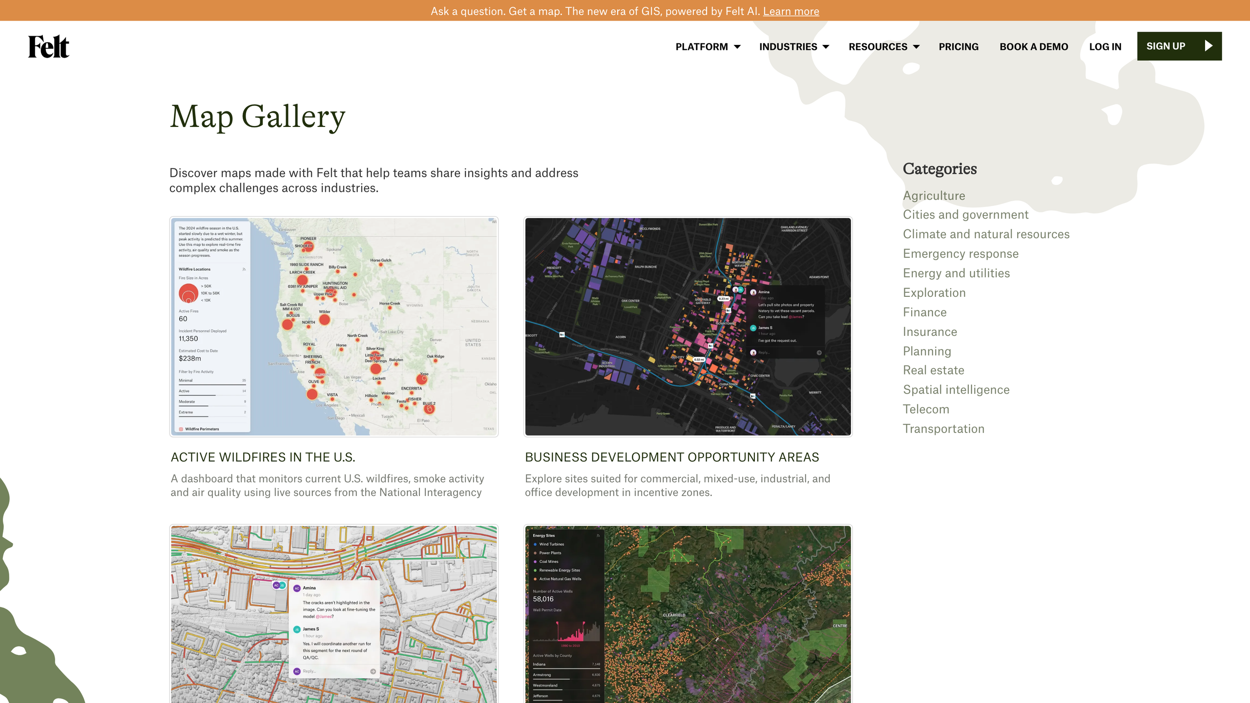
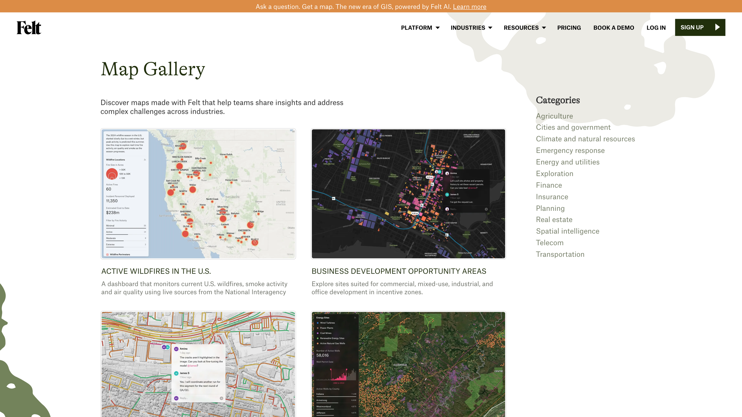
Real-time collaboration and sharing. Multiple people can edit the same map at once (live cursors), with threaded comments plus guest and public commenting. Permissions exist at project and workspace level, with admin/editor/viewer roles and view-only or comment-only options. Sharing ranges from view-only links and public maps to iframe embeds (optionally auth-gated) — what Felt calls "zero-click sharing." The official Map Gallery shows public examples (screenshot below): map cards on the left — for instance a live dashboard tracking active U.S. wildfires, smoke and air quality — with industry categories such as agriculture, cities and government, and emergency response on the right.
Dashboards and spatial analysis. Maps can carry charts, statistics, filters, H3 hexagonal aggregation and time sliders, forming dashboards that stay in sync with the underlying data; spatial transformations include buffer, intersect, union and raster calculations. Felt describes this as "how BI should be for geospatial."
Field data collection. The iOS/Android field app captures GPS tracks, geotagged photos and survey forms, works offline, and syncs live to the map back at the office (pricing page FAQ).
Accounts and openness
Felt connects deeply with professional GIS workflows: the "Add to Felt" QGIS plugin installs from the official QGIS plugin repository and publishes QGIS layers to Felt with styling and symbology preserved — the official pitch is "analyze in QGIS, share on Felt." Felt is a Flagship-level Sustaining Member of QGIS and sponsors development of Tippecanoe, the open-source tile builder its stack is built on (alongside MapLibre).
Developer capabilities sit in the Enterprise tier: live-synced layers from Postgres/PostGIS, Snowflake, Databricks, BigQuery and Amazon S3 (COGs, GeoParquet); a REST API and JavaScript SDK to read and write features, manage maps and embed Felt inside your own product; an MCP server that lets AI assistants such as Claude and ChatGPT build maps from a prompt; plus custom JavaScript extensions and webhooks. Both paid tiers include Felt Server, a self-hosted runtime (one instance on Professional, unlimited on Enterprise). Felt AI, launched in 2025, turns a map into an interactive app with buttons, panels and logic from a natural-language prompt (Extensions) — the vendor claims 75% shorter deployment times — and AI map creation and analysis are Enterprise-only.
On exports: every plan can export Shapefile, GeoJSON, GeoPackage, GeoTIFF, CSV and high-resolution images at any time, and the FAQ explicitly disavows lock-in; live-connected warehouse data is read-only and never leaves your warehouse, and you can take all data with you on cancellation (pricing page FAQ).
Pricing
As of 2026-09-25, the official pricing page lists three tiers, but paid plans have no published prices and are sold as annual contracts only:
| Tier | Price | Key features and limits |
|---|---|---|
| Personal | Free | Unlimited maps and sharing; no uploading your own data files and no commercial use of any kind (employer work, client projects, freelance all excluded) |
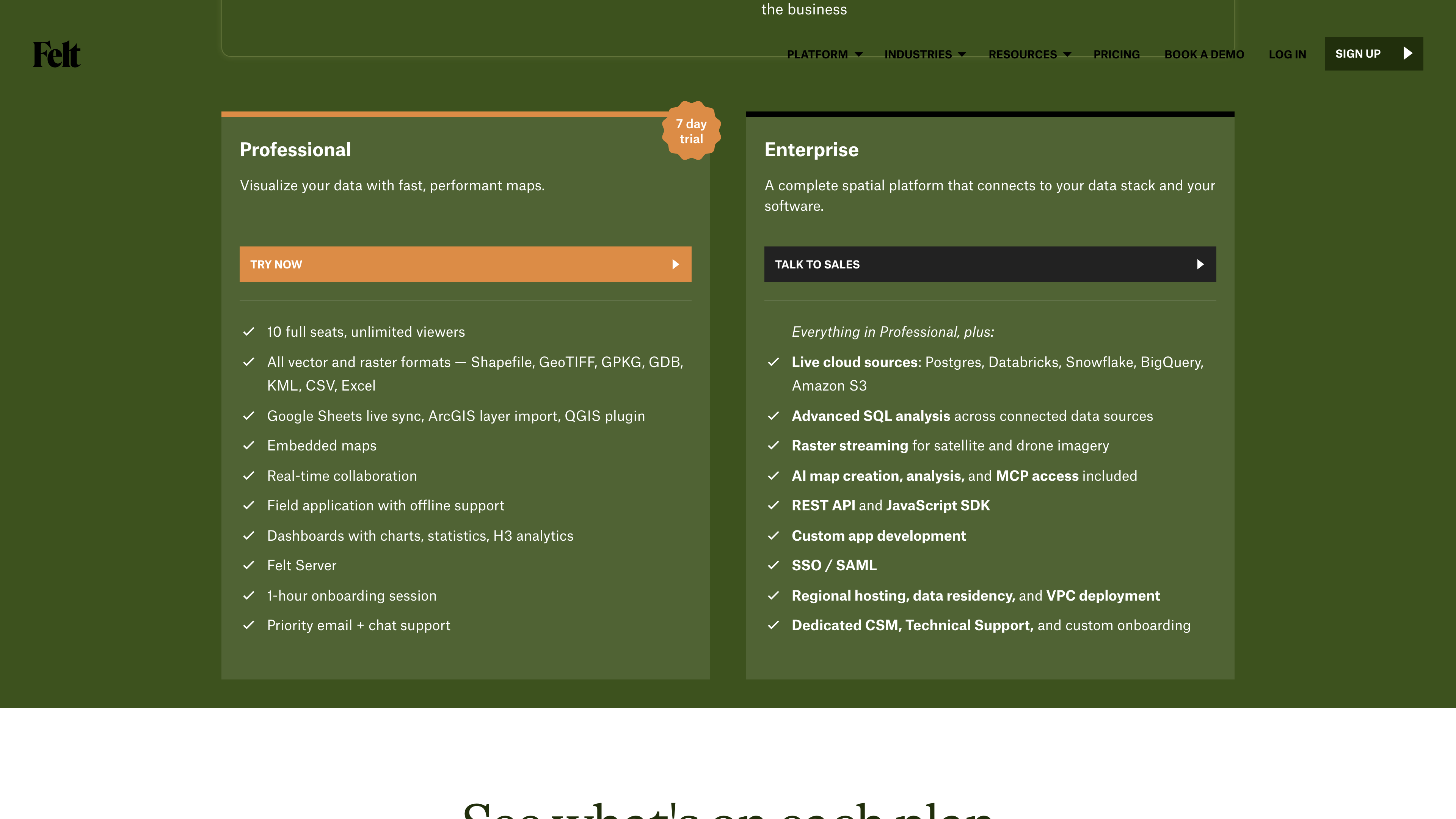
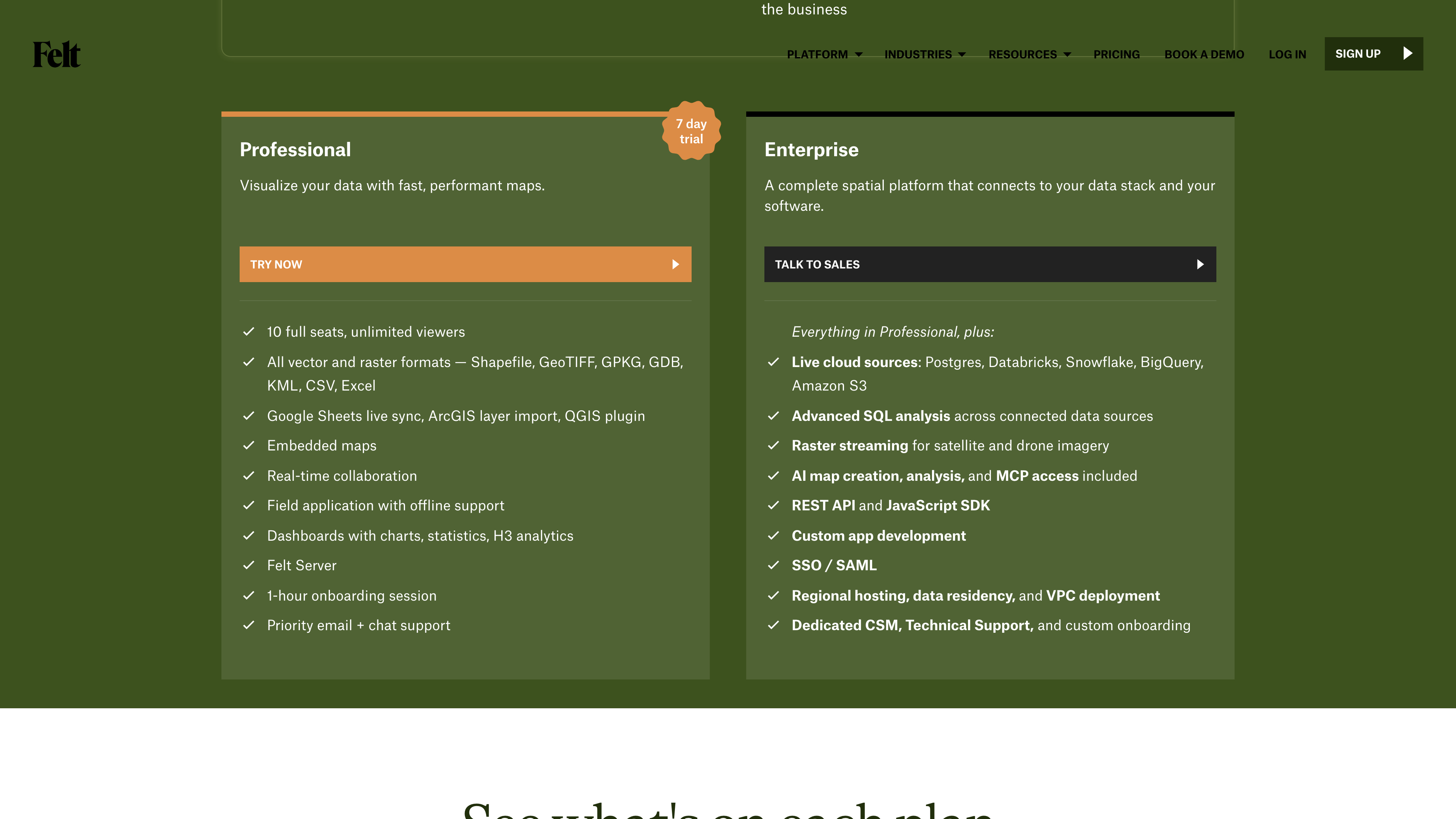
| Professional | Unpublished (annual; 7-day trial, no credit card) | 10 full seats included plus unlimited free viewers; 25 GB/month data processing and 100K map views/month; QGIS plugin, embedded maps, field app, dashboards |
| Enterprise | Custom | Live cloud sources, advanced SQL analysis, raster streaming, Felt AI and MCP, REST API/JS SDK, SSO/SAML, regional hosting and VPC deployment, dedicated CSM |
Also of note: verified U.S. 501(c)(3) nonprofits get 30% off; education (classrooms, students, professors) is free. Overages are not auto-billed and maps are not throttled — Felt says it reaches out to discuss upgrading instead.
Security and terms
Per the security page: Felt has a SOC 2 Type II report; traffic is TLS-encrypted and data encrypted at rest; data is stored in the U.S. by default (versioned AWS S3 buckets plus Render's Oregon datacenter); annual third-party penetration testing; Enterprise adds EU regional hosting, data residency and VPC deployment; Google sign-in, SAML/SSO and revocable personal access tokens (PATs) are supported.
The Terms of Service follow a typical B2B SaaS structure: customers keep all rights to their Customer Data (explicitly including map and GIS data content); Felt owns the IP in Usage Data and may freely use aggregated, de-identified data; seat licenses are personal and non-transferable; customer data may be deleted after 90 days of delinquency; free and trial offerings are provided as-is with liability capped at $100; California law applies with exclusive jurisdiction in San Francisco courts. The Privacy Policy (effective 2021-11-01) says personal data is retained at most 12 months after account termination, processed in the U.S., and used with Google Ads remarketing; it lists country-specific minimum ages from 13 to 18, and provides a DMCA takedown contact (support@felt.com).
Good fits
- GIS analysts and consultancies that analyze in QGIS and need to share results with colleagues or clients quickly.
- Teams that need real-time collaborative mapping, public embeds, or public commenting (urban planning, emergency response, environment).
- Data teams that want warehouse spatial data in Postgres/Snowflake turned straight into dashboards and apps (Enterprise).
- Energy, utility and government field crews collecting data offline (line inspections, assets, damage assessment).
- Personal, non-commercial projects (thru-hike planning, a travel map for friends) on the free Personal plan.
Limitations
- Opaque, annual-only pricing: Professional and Enterprise both require talking to sales; no month-to-month flexibility.
- The free tier can't upload data and bans commercial use: Personal suits hobby mapping only; anything work-related requires payment.
- Key capabilities are Enterprise-locked: live warehouse connections, REST API/JS SDK, AI/MCP and SSO all sit in the top tier, out of reach for small teams.
- English only: the site, app and help center have no Chinese or other-language interface.
- Closed-source cloud service: data is U.S.-hosted by default (regional hosting requires Enterprise); Felt Server is a self-hosted runtime, not the whole platform, so availability depends on the vendor.
- Collaboration over analytical depth: Felt itself recommends keeping heavy analysis in QGIS — it does not replace the full desktop GIS role; customer-outcome figures on the site (such as "75% faster deployment") are vendor-reported and not independently verified.
Alternatives
- Esri ArcGIS Online: the industry's de facto standard, deepest in features and ecosystem but more complex and costly; Felt's FAQ directly addresses ArcGIS import and migration, targeting its collaboration gaps.
- CARTO: another cloud-native spatial analytics platform built around warehouse connections; stronger on analysis, weaker on collaborative mapping.
- Mapbox: a developer-focused basemap and location API platform for custom maps and location apps, without a Felt-style team workspace.
- QGIS: the free, open-source desktop GIS with comprehensive analysis; Felt complements it via an official plugin rather than replacing it.
References
- Felt homepage (checked 2026-09-25)
- Felt Pricing (checked 2026-09-25)
- About Felt (checked 2026-09-25)
- Felt Security (checked 2026-09-25)
- Terms of Service - Felt Help Center (checked 2026-09-25)
- Privacy Policy - Felt Help Center (checked 2026-09-25)
- QGIS plugin - Felt Help Center (checked 2026-09-25)
- Felt Map Gallery (checked 2026-09-25)
- Felt AI unleashed - Felt Blog (checked 2026-09-25)
- Felt Raises $15M to Transform Enterprise GIS with AI - PR Newswire (checked 2026-09-25)
- Felt raised $4.5 million to get you to 'think in maps' - TechCrunch (checked 2026-09-25)
- Felt's $15 million chance to prove that maps are the next big medium - TechCrunch (checked 2026-09-25)